


The City of Utica announced the launch of a road paving assessment initiative, according to a press release posted by the Mayor’s office on Jan. 13.
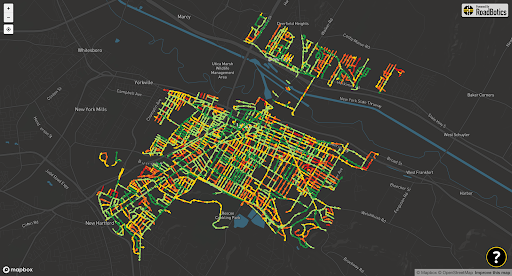
Information collected from the assessment will guide the city on which roads will be included in Utica’s annual road repair and paving program, the city said. Additionally, the initiative introduces six interactive maps displaying road conditions throughout the city.
“When campaigning for mayor I knew it was essential to improve the paving process in the City of Utica,” Mayor Mike Galime said in a statement. “This required a clear understanding of the conditions of every road.”
The first of the six interactive maps gives a general overview of Utica’s road segments and their conditions. Road quality is measured on a scale of 1 through 5 (from low to high, respectively). On the map, these ratings are represented by various categorized colors.
Dark green segments represent roads with an overall rating of 1- indicating minor surface distress. In contrast, red segments represent roads with major surface damage. By clicking on each category, this will show where they’re located on the map.
If a user zooms in on a particular segment, they can view the details of the roads’ evaluation including street-view photographs and explanations. Zoomed in, users can view the road quality of each segment section and the segment’s overall rating.
To gather the data for the interactive maps, the engineering department used artificial intelligence and contracted technology from Michelin Better Roads.
“With Michelin’s expertise and advanced technology, this data-driven approach ensures the City is well-positioned to maximize its impact of its annual paving resources,” Galime said. “Additionally, thank you to the hard work of the engineering department for their assistance in making this vision a reality.”
The city encouraged feedback from the community to ensure that the assessments match what residents experience on the roads, the press release said.
“This comprehensive assessment and its public accessibility mark an important step forward,” Galime said.
To access the interactive map, residents of the Utica community can visit the initiative’s website at PaveUtica.com or bit.ly/uticaroads.